Zone 2 includes the counties of:
- Alger, Mich.
- Baraga, Mich.
- Chippewa, Mich.
- Delta, Mich.
- Dickinson, Mich.
- Florence, Wis.
- Forest, Wis. (northern portion)
- Gogebic, Mich. (eastern portion)
- Houghton, Mich.
- Iron, Mich.
- Keweenaw, Mich.
- Luce, Mich.
- Mackinac, Mich.
- Marinette, Wis. (northern portion)
- Marquette, Mich.
- Menominee, Mich. (northern portion)
- Ontonagon, Mich. (eastern portion)
- Schoolcraft, Mich.
- Vilas, Wis. (northern portion)
TThe physical boundaries of Zone 2 and transmission facilities located in Zone 2 are shown in Figure ZS-23.
Land use in Zone 2 is largely rural and heavily forested.
Zone 2 typically experiences peak electric demands during the winter months. Ore mining and paper mills are the largest electricity users in the zone.
Demographics
The population of the counties in Zone 2 experienced slightly negative growth from 2000 to 2010. The highest growth rate of 0.5 percent per year and the largest increase in population of 1,000 occurred in Vilas County.
Population in Zone 2 is projected to grow on an annual basis of 0.2 percent between 2010 and 2020. For the same period, Vilas County is projected to realize the largest increase in population of about 1,600, as well as the highest growth rate (0.7 percent).
During the same period, the annual employment also had a slightly negative growth rate of -0.3 percent. The highest growth rate and the highest increase in employment were in Marquette County (Michigan).
Employment in Zone 2 is projected to grow at 0.8 percent annually between 2010 and 2020. During this time period, Marquette County (Michigan) is projected to realize the largest increase in employment of over 4,100, while Luce County (Michigan) is projected to have the highest growth rate 0f 1.6 percent.
Zone 2 environmental considerations
Zone 2 includes a small part of the far northeast portion of Wisconsin and approximately the eastern two-thirds of the Upper Peninsula of Michigan. The Wisconsin portions of the zone fall into the Northeast Sands and North Central Forest ecological landscape regions. The portions of the zone located in Michigan are part of the Eastern Upper Peninsula eco-region. A description of the characteristics of the Eastern Upper Peninsula eco-region may be found on the Michigan Department of Environmental Quality Web page at http://www.michigan.gov/dnr/0,1607,7-153-10366_11865-31471--,00.html.
Large expanses of this zone are forested and there are large numbers of streams, lakes and wetlands throughout the zone. The Niagara Escarpment is situated in the Eastern Upper Peninsula. Lakes Superior, Huron and Michigan form the northern and eastern boundaries of the zone. Two Michigan State Natural Rivers (Fox and Two-Hearted) and nine National Wild and Scenic Rivers (Tahquamenon, Indian, Sturgeon, Whitefish, Yellow Dog, Ontonagon, Paint, Carp and North Sturgeon) are found in this zone. Portions of the Nicolet, Ottawa, and Hiawatha national forests, and numerous state forests and parks are found in this zone. Several Indian reservations are found in this zone. The Seney National Wildlife Area, Pictured Rocks National Lakeshore and numerous federal wilderness areas also are found in this zone.
Zone 2 electricity demand and generation
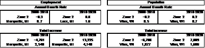
The coincident peak load forecasts for Zone 2 for 2011, 2015, 2020 and 2025 are shown in Table ZS-9. Existing generation along with proposed generation based on projected in-service year are also shown. The resultant capacity margins, with or without the proposed generation, are shown as well.
This table shows that load is projected to decrease at roughly 0.75 percent annually from 2011 through 2020. Comparing load with generation (at maximum output) within the zone indicates that Zone 2 has more generation than peak load, though actual operating experience indicates that during most periods, Zone 2 is a net importer of power.
Zone 2 transmission system issues
Key transmission facilities in Zone 2 include:
- Morgan-Plains and Plains-Dead River 345-kV lines,
- Plains-Stiles 138-kV double-circuit line,
- Conover-Plains 138-kV line, and
- 138-kV facilities tying the Upper Peninsula of Michigan to the Lower Peninsula.
Transmission study drivers
An overriding general characteristic of the Zone 2 transmission system is the fact that it consists of load islands dispersed over a broad area and numerous components are near limits. Both the local and interconnecting components of this network have been generally adequate by historic standards, however, modern performance requirements, coupled with load increases or generation reductions of "modest" magnitudes could result in reinforcement needs. Furthermore, the inability to immediately serve nominal growth or generation changes could emerge. This indicates the need for extensive Strategic Flexibility analysis which requires the inclusion of varied internal and external factors. This is the basis for conducting the ATC Energy Collaborative – Michigan study process which contributes to the Zone 2 analysis in this 10-Year Assessment.
Key system performance issues in Zone 2 include:
- Proposed renewable generation source increases,
- Proposed point load increases,
- Proposed generation retirements,
- Limited import and export capability,
- Aging 69-kV and 138-kV infrastructure throughout the Upper Peninsula,
Generator stability in the central portion of Upper Peninsula,
- Parallel path flow around Lake Michigan that contributes to heavy loading on the 138-kV and 69-kV systems, and results in the need for transmission loading relief incidents and reconfiguration of the system,
- Record low Lake Superior water levels in previous years have resulted in potentially reduced hydro generation, output in the eastern U.P., magnifying reliability concerns in this area,
- High voltage concerns at lighter load periods for central and eastern Upper Peninsula,
- Low voltages, most pronounced in the western and eastern Upper Peninsula,
Potential low voltages and overloads in the northwestern U.P. due to recent load increases, and
- Potential marginal voltages and overloads in the central U.P. due to potential load increases.
Please refer to the ATC Energy Collaborative – Michigan for more information on the application of strategic flexibility planning to Zone 2.
|