Zone 3 includes the Wisconsin counties of:
- Columbia
- Crawford (southern portion)
- Dane
- Dodge
- Grant
- Green
- Iowa
- Lafayette
- Jefferson
- Richland
- Rock
- Sauk
- Walworth and
- Winnebago, Ill. (northern portion)
The physical boundaries of Zone 3 and transmission facilities located in Zone 3 are shown in Figure ZS-24.
Land use in Zone 3 is a mix of rural, urban and agricultural.
The major population centers are the Madison metropolitan area and the Janesville/Beloit area.
Zone 3 typically experiences peak demands during the summer months. Manufacturing, food processing, state government and institutional loads are among the largest electricity users in the zone.
Demographics
The population of the counties in Zone 3 grew at an annual rate of 1.0 percent from 2000 to 2010. The highest growth rate of 1.5 percent per year and the largest increase in population of 70,100 occurred in Dane County.
Population in Zone 3 is projected to grow at 1.1 percent annually for the 2010 to 2020 period. From 2010 to 2020, Dane County is projected to realize the largest increase in population (82,300) and is projected to have the highest growth rate of 1.5 percent.
During the same period, the annual employment growth rate was 0.9 percent. The highest growth rate (1.4 percent) and the largest increase in employment (51,000) occurred in Dane County.
Employment in Zone 3 is projected to grow at 1.3 percent annually between 2010 and 2020. Dane County is projected to realize the largest increase in employment of over 62,000 and Sauk County the highest growth rate of 1.6 percent.
Zone 3 environmental considerations
Zone 3 covers the south central and southwestern portions of Wisconsin and the Illinois county of Winnebago.
The ecological landscapes in this zone vary from Southeast Glacial Plains in the east through the Central Sand Hills area to areas that are part of the Southwest Savanna and Western Coulee and Ridges landscapes in the west. The eastern portions of the zone generally are level to gently rolling terrain, while the western areas are characterized by the ridges and valleys of the driftless area.
The northern and western portions of this zone are located in the Lower Wisconsin River Drainage Basin, and the Mississippi River forms the zone’s western boundary. Other portions of this zone are located in the Grant-Platte, Sugar River-Pecatonica, Upper and Lower Rock and Fox Illinois drainage basins. Horicon Marsh National Wildlife Refuge is located in the northeast part of the zone, and the Upper Mississippi River Wildlife and Fish Refuge is located along the zone’s western edge. The Baraboo Hills are located in the north-central portion of the zone. The Lower Wisconsin River State Riverway also is found in this zone.
Zone 3 electricity demand and generation
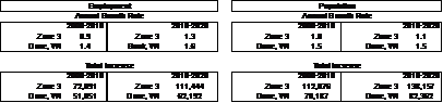
The coincident peak load forecasts for Zone 3 for 2011, 2015, 2020 and 2025 are shown in Table ZS-10. Existing generation, along with proposed generation based on projected in-service year, also are shown. The resultant capacity margins, with or without the proposed generation, are shown as well.
The table shows that load is projected to grow at roughly 2.2 percent annually from 2011 through 2020. Comparing load with generation (at maximum output) within the zone indicates that Zone 3 has more generation than peak load during peak load periods. However, actual operating experience indicates that during most load periods, Zone 3 is a net importer of power.
Zone 3 transmission system issues
Key transmission facilities in Zone 3 include:
- Columbia-North Madison 345-kV lines,
- Columbia-Rockdale 345-kV line,
- Paddock-Rockdale 345-kV line (in-service spring 2010),
- Paddock-Wempletown 345-kV line,
- Rockdale – Wempletown 345-kV line, and
- 138-kV facilities from the Nelson Dewey Power Plant, around the Madison area, and in the northwest and southeast portions of Zone 3.
Key system performance issues in Zone 3 include:
- Existing contingency thermal overloads on the Fitchburg-Royster 69-kV line,
- Low voltages and line overloads on the 69-kV system in Monroe area in 2011,
- Contingency low voltage issues on the Sheepskin-Bass Creek-Brodhead 69-kV line in the 2013 timeframe,
- The 2013 Rockdale-Cardinal 345-kV line project is planned to address thermal constraints and low voltage issues in Madison area,
- The West Middleton-Stage Coach 69-kV line requires higher capacity under contingency conditions in 2015,
- Intact system 138- and 69-kV low voltages in Jefferson and Dane Counties are an emerging issue in 2015 and beyond,
- Insufficient 69-kV line capacity in Walworth County in 2016,
- Low voltages and line overloads on the 69-kV system in the Dam Heights area,
- The existing Hillman 138/69-kV transformer potentially overloads in 2018 under single contingency in the Dairyland Power system, and
- Even with some new 138-kV capacitor bank installation in 2011, the North Madison-Columbia 345-kV double circuit line outage could cause severe low voltage limitations in 2020 timeframe.
|