Zone 1 includes the Wisconsin counties of:
- Adams
- Forest (southwestern portion)
- Fond du Lac (northwest portion)
- Green Lake
- Juneau
- Langlade
- Lincoln
- Marathon
- Marquette
- Monroe (eastern portion)
- Oneida
- Portage
- Shawano (western portion)
- Vernon (eastern portion)
- Vilas (southern portion)
- Waupaca
- Waushara
- Winnebago (western portion)
- Wood
The physical boundaries of Zone 1 and transmission facilities located in Zone 1 are shown in Figure ZS-22.
Land use in Zone 1 is largely rural, including agricultural and forested areas.
Zone 1 typically experiences peak electric demands during the summer months, with some winter peaks appearing in the northern portion. Primary electricity users in Zone 1 include a number of large paper mills and food processing plants.
The major population center in the area is Wausau.
Demographics
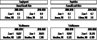
The population of the counties in Zone 1 grew at an annual rate of 0.3 percent from 2000 to 2010. The highest growth rate occurred in Juneau County, which grew at 1.1 percent, while the highest increase in population occurred in Marathon County, which increased 6,600 people over the period.
Population in Zone 1 is projected to grow at 0.7 percent annually for the 2010 to 2020 period. Marathon County will realize the largest increase in population (8,100), while Adams County will have the highest growth rate of about 2.0 percent.
During the historical period of 2000 to 2010, the annual employment growth rate was 0.5 percent. The highest growth rate occurred in Adams County (2.4 percent), while the largest increase in employment occurred in Marathon County of over 5,800.
Employment in Zone 1 is projected to grow at 0.9 percent annually between 2010 and 2020. From 2010 to 2020, Marathon County is projected to realize the largest increase in employment of about 7,800, while Adams County is projected to have the highest growth rate (2.0 percent).
Zone 1 environmental considerations
Zone 1 covers the central and north-central portions of Wisconsin and spans a wide range of ecological landscapes varying from the Northern Highland and North Central Forest regions in the northern part of the zone through the Forest Transition, Central Sand Plains and Central Sand Hills regions to the Western Coulee and Ridges region in the southern portions of the zone. Descriptions of the characteristics of each of these ecological landscapes may be found on the Wisconsin Department of Natural Resources Web site: http://dnr.wi.gov/landscapes/
The northern portion of the zone contains numerous lakes and woodlands, while the southern portion is more agricultural in nature. Lands in this zone primarily are located in the Upper and Central Wisconsin River drainage basins with smaller portions of the zone located in the Fox and Wolf River drainage basins. The Necedah and Fox River National Wildlife Refuges, a small portion of the Nicolet National Forest and several Indian reservations are located in this planning zone.
Zone 1 electricity demand and generation
The coincident peak load forecasts for Zone 1 for 2011, 2015, 2020 and 2025 are shown in Table ZS-8. Existing generation, along with proposed generation based on projected in-service year, also is shown. The resultant difference between load and generation, with or without the proposed generation, is shown as well.
The table shows that load is projected to grow at roughly 1.1 percent annually from 2011 through 2020. Comparing load with generation (at maximum output) within the zone indicates that Zone 1 is a net importer of power during peak load periods.
Zone 1 transmission system issues
Key transmission facilities in Zone 1 include:
- East-west 345-kV line from Arpin Substation through Stevens Point extending to the Appleton area,
- 345-kV line extending from Wausau to northeastern Minnesota,
- 345-kV line extending from Wausau to Stevens Point to eastern Outagamie County (Highway 22),
- 115-kV network in the northern portion of the zone, and
- 138-kV and 69-kV network in the southern portion of the zone.
Key system performance issues in Zone 1 include:
- Low voltage and thermal overloads in the Petenwell, McKenna and Plainfield areas,
- Low voltage and thermal overloads in the Wautoma, Metomen and Winneconne areas, and
- Transformer overloads at Harrison and Caroline Substations.
|